


SKU/Artículo: AMZ-B0B5VQB17H
Brunton
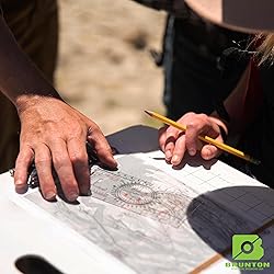
Brunton Map Multi-Tool – Field Card for Plotting Bearings & UTM/Map Coordinates (Protractor, UTM Grids, Common Map Scales, Inch/cm Rulers, Strike-&-Dip Crosshairs) – Waterproof, Ultralight
Detalles del producto
Disponibilidad:
En stock
En stock
Peso con empaque:
0.15 kg
0.15 kg
Devolución:
No
No
Condición
Nuevo
Nuevo
Producto de:
Amazon
Amazon
Viaja desde
USA
USA
Sobre este producto
- The Brunton Map Multi-Tool combines rulers, map scales, UTM grids, and protractors all into one handy tool. It features a unique protractor for measuring or plotting angles on maps and a unique strike and dip crosshairs cutout in the center. The rulers are in inches and centimeters, and the map scales and UTM grids are in several common international map scales. Unique cutouts make it easier to plot points or lines on maps. The Map Multi-Tool easily fits into field pouches, vest pockets, or field notebooks for safe storage when not in use.
AR$64.436
49% OFF
AR$33.044
IMPORT EASILY
By purchasing this product you can deduct VAT with your RUT number
AR$64.436
49% OFF
AR$33.044
con envío
Este producto viaja
de USA ![]() a tus manos en
a tus manos en
![]()
Conoce más detalles
Waterproof, durable, lightweight card can handle exposure to any type of weather Inch/10ths and cm/mm rulers Romer Scales for UTM grids at various map scales Map rulers for various map scales 360˚ protractor with azimuth (0-360) and quadrant (0-90) markings
Compra protegida
Disfruta de una experiencia de compra segura y confiable
Tarjetas de Crédito y Débito
Visa
Mastercard
American Express
Pagos a través de PayPal
Compra procesada en dólares con dinero en cuenta o tarjetas internacionales.
Paypal
Pagos a través de MODO
Compra procesada en pesos desde la App de tu banco.
PayPal

